Iceland (III): the Viking Sushi Tour (West)

If you plan to visit just one town in the Snaefellsness Peninsula, I recommend Stykkisholmur. Arthur and I love seafood and sushi, so imagine our excitement when I found out about the Viking Sushi tour in town!

It was a sunny afternoon, blue sky at 55F, the weather couldn’t be better.

Bundled up in warm layers, we enjoyed ourselves up on the deck. If you don’t like wind and cold, they provided inside cabin downstairs to keep you warm and cozy.

We sailed pass a couple of small islets, our captain navigated the boat so close to the shore we could almost touch the cliff!

We saw three different kinds of birds nesting on the cliff, no puffins though.

The islets were delightful.  However, the crowning point of the tour was neither the birds nor the beautiful scenery!

Raw seafood tasting, Viking style, stole the show!

A big net was thrown into the ocean, then dragged up a few minutes later, taking with it a rich load of goodies!

There were scallops, sea urchins, starfish, crabs and mussels. Right on the boat they just cracked open the scallops and sea urchins, and handed over the scallop meat and roe of sea urchins to us!

And soy sauce, wasabi, ginger and chopsticks were provided.

We had NEVER had anything like that, so FRESH and so DELICIOUS!

Look at all the empty shells on the table!

The red sea urchin was pretty, but not edible. Also the mussels were not suitable to eat raw either.

We couldn’t finish them all, at the end the unconsumed sea creatures and all the empty shells got returned back to the ocean where they belonged.

IMG_1356(p)

The tour lasted two and half hours. Since we couldn’t have mussels on the boat, we had steamed Icelandic blue mussels for dinner at a restaurant by the dock.  It was nice to dine on cooked food again, hard to sustain on Viking diet.

Our tummies were full.  Content and sated. Let’s call it a day!

Iceland (II): the Iconic Image of Mt. Kirkjufell

How to capture the iconic image of Mt. Kirkjufell and Kirkjufellfoss

Mt. Kirkjufell together with the Kirkjufell waterfall has become the iconic image of West Iceland, taking this shot was on my list of must-do in Iceland.

Only when I got to the location, I learned just how particular this shot was.

Mt. Kirkjufell #1

If you came from Snaefellsjokull National Park direction like us, Mt. Kirkjufell had no tip but a flat top.  The mountain displayed its iconic shape only at the angle after we passed it.

Mt. Kirkjufell #2

Not only that, the Kirkjufellsfoss, the waterfalls, were on the other side of the road.

The waterfalls were not by the mountain at all.

Mt. Kirkjufell #3

This shot was taken from the small bridge on top of Kirkjufell waterfalls; Kirkjufell mountain was on the other side of the road, left to the parking lot.

Only when you crossed the small bridge, standing on the left side (where all the people standing), then angled your camera to include both the mountain and the falls–Voila, you got the shot!

Mt. Kirkjufell and Kirkjufellsfoss

Ideally, during the sunset is the optimal time of the day to shoot Mt. Kirkjufell.  You would have colorful sky as the backdrop. We were not lucky that day.

On the way to Mt. Kirkjfell, Grudarfjordur, we stopped at Olafvik for lunch.  There we found a local soccer field.

Olafvik Soccer field #1

And an ultra modern church by the soccer field.

Olafvik Church

Mountains, glaciers, waterfalls, clean air and church, all must have somehow contributed to the outstanding performance of Icelandic soccer team in 2018 World Cup!

Iceland (I): Hiking the Glymur, the Highest Waterfall in Iceland

We just got back from 12-day trip in Iceland.  What a BEAUTIFUL country! If you love nature and outdoor, and photography, Iceland is for you!  

We just got back from 12-day trip in Iceland.  What a BEAUTIFUL country! If you love nature and outdoor, and photography, Iceland is for you!  For a country only the size of Virginia State, Iceland is packed with stunning beauty! In 12 days we circled the whole country along the 800-mile Ring Road, starting from the capital Reykjavik going clockwise to the west, the north, the east and ending at the popular south.

We hiked the Glymur waterfall (or foss in Icelandic) on the second day, it was a highly anticipated hike! 🙂

There was a description of the hike at the parking lot, and the signs were well posted at each critical turn.

The hike was flat but scenic on the first mile.  It was an easy strolling until we reached an open cave.  Through the cave opening we spotted the Botnsa river, this was the river we would trail along to get to the foss.

The glacier water from the Botnsa river was so clear and refreshing.  We filled up the water bottle, we would need it soon.

IMG_8110
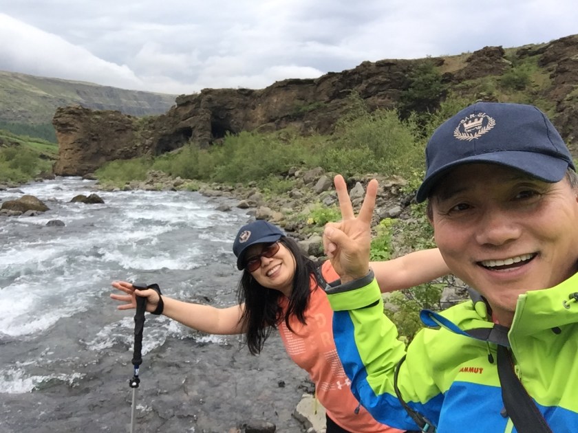
Both banks of the Botnsa river lead to the foss, however the right bank offered a better view of the foss.  A rope and a wood log were installed to help the hikers to cross the river.  The water was REALLY COLD!

After the river crossing, the path took a turn to strenuous ascension.  I had to hold on to the rope, it was quite steep.  At some area, we hiked on the narrow dirt path right along the dropping cliff! I don’t know about you, but looking back down to the river we just crossed, the cave openings looked like a pair of eyes, watching us…

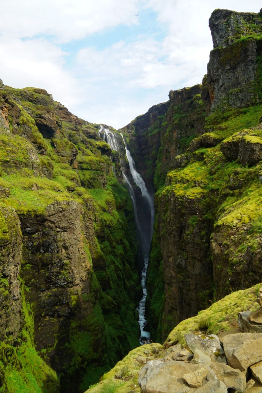
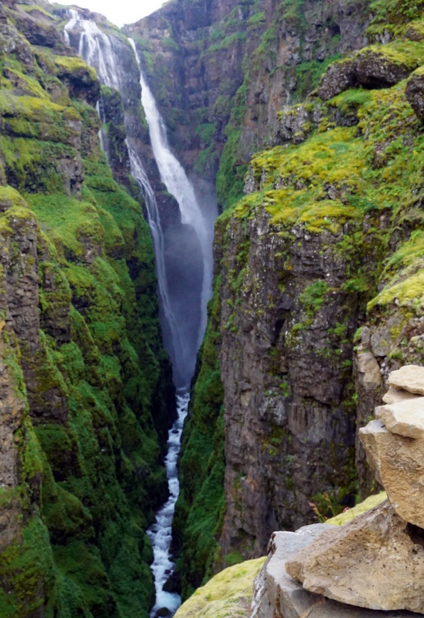
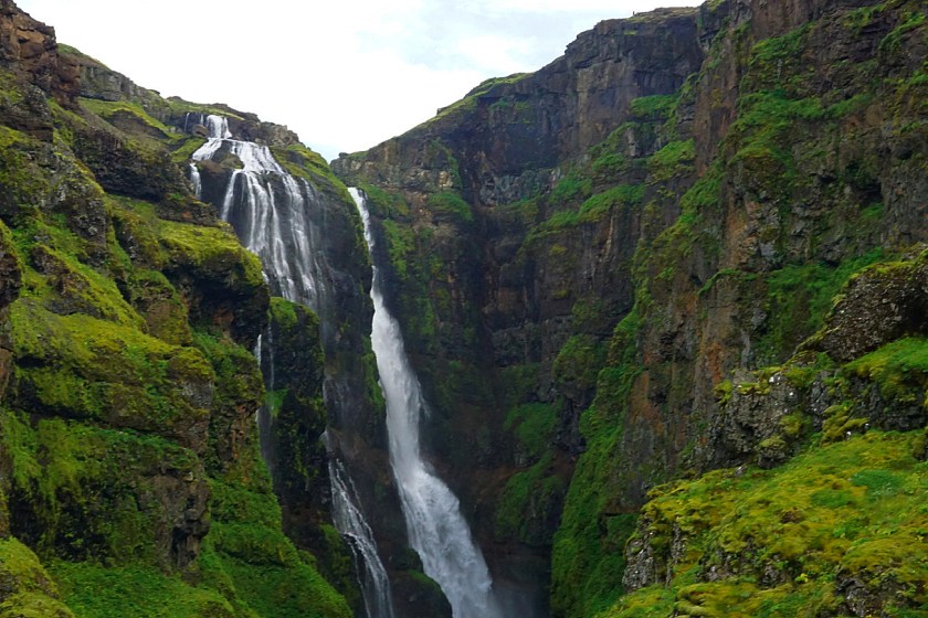
Soon we spotted the vapor from the waterfall in the distance. With the waterfall in front of us, we kept going, up and up.

DSC06196

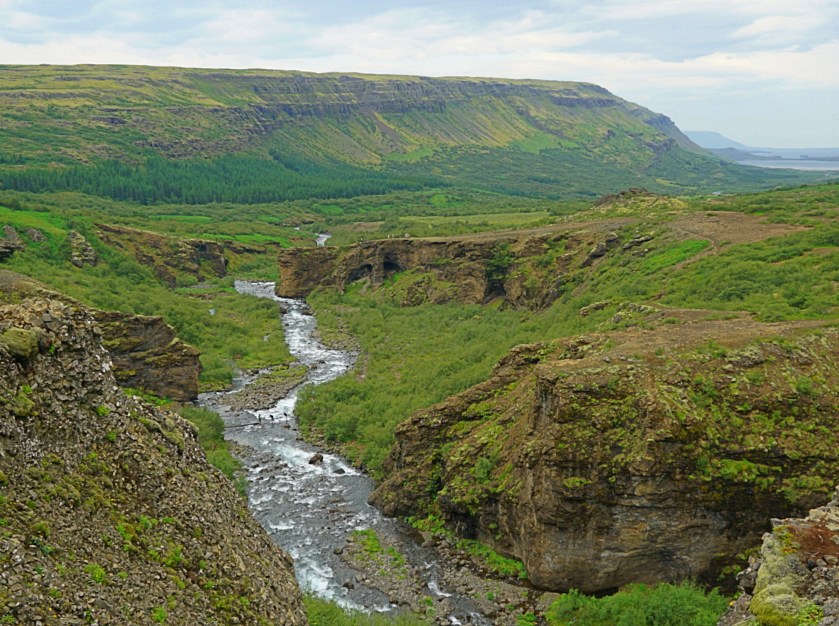
Occasionally we paused to see how much we had accomplished. Can you spot people crossing the Botnsa river way down there?  The up right corner near the fjord was where we parked our car!

DSC06240

DSC06248

DSC06250

In the following hour, we hiked and climbed.  Can you see the tiny people on the top of the cliff on the right? We would be in their position, soon!

For most part of hiking, the waterfall was in view except a few zigzag sharp turns we lost track of it. Again ropes were there to assist the hikers, very helpful!  Some no-name waterfalls were spilling here and there.

Almost there!

DSC06265

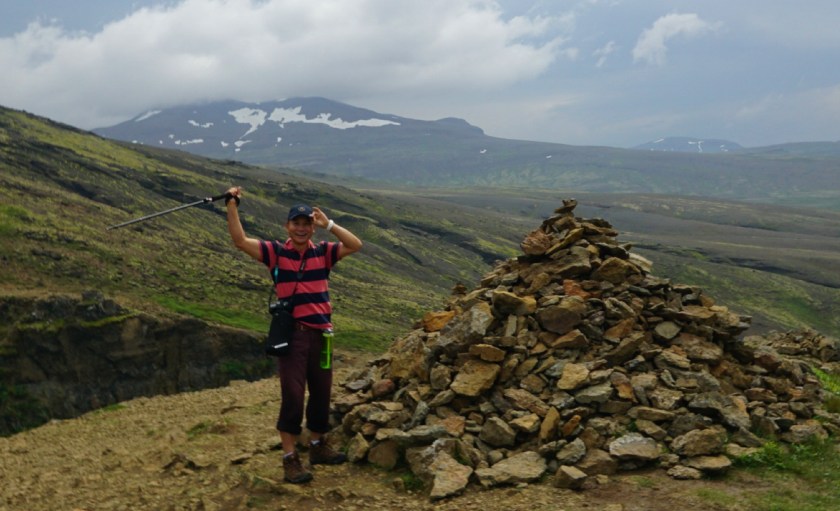
And we did it! We conquered the Glymur, the highest foss in Iceland, Hooray!! Look at the people on other side of the falls, we decided to join them.  We found a shallow area and trod across the Botnsa river again, this time at the upstream of the Glymur fall!

Beware plodding across the Botnsa river, the water was not as shallow as some suggested: it came all the way up to Arthur’s knees and to my thighs!

Now take a good look at the waterfall at this side of the bank before descending.  It was all worth it!!

DSC06271

After another long hour, we finally saw that open cave! So happy to see that pair of watchful eyes again!

IMG_1919 The whole hike from the parking lot back to the parking lot took us 4 hours to complete.  It was four-hour well spent!

A few things about the hike:

(1) I am glad that we took the hike at the beginning of our trip.  We followed Rick Steves’ suggestion, going west first driving clockwise on the Ring Road.  We were quite energetic.  If we did south first and Glymur at the end of the journey, it might be a different story.  So keep that in mind when you plan your trip.

(2) Glymur is a little more than an hour in the west of Reykjavik, so it can be a good day trip if you stay in Reykjavik. We did the hike in the morning, when we were done the parking lot was full. So do it in the morning to avoid the crowd.  It took us four hours because we took a few breaks here and there, it could be done in a shorter time.

(3) According to Extreme Iceland, Glymur used to be the highest waterfall in Iceland, with the height of 196 m, until recently a higher waterfall ‘Morsi’ in highland Morsarjokull glacier was discovered.  Because the new #1 is not well known and less accessible (I googled it but failed to find a photo of it),  people still call Glymur the highest waterfall in Iceland.

According to Google, there are more than 10,000 waterfalls in Iceland!!  I am a waterfall fanatic, we also hiked the Hengifoss,  the second highest waterfall (128m), when we were at Northeast Iceland.

A Bermuda Beach Day (II)

The beauty of Bermuda blows me away!  With blush pink sands, turquoise water and remarkable coves, there are nothing quite like the beaches in Bermuda!

We spent our second day in Bermuda at the beach.  We chose the Horseshoe Bay beach since it is one of the most applauded beaches in Bermuda.

IWEG1642

Most of the cruise people went there, consequently it was much more crowded than other beaches.

Facing the water to the right side of the beach is the Horseshoe Bay Cove.  There rocky terrain rising above the bay encircles the clear water to shape the cove,  it’s like a solitude within a retreat.

DSC05110 (2)

When we arrived in the early morning, we were the only ones at the cove.

So to avoid the crowd, go there early and venture out.

DSC05123

We also walked to the left side of the Bay.  It was even better!  So seclusive, some part of the beach felt like a private one because we were the only ones there!

One thing for sure, the further away from the Horseshoe Bay, the more striking the scenery, the rockier the beach.

If you want to venture out the beach area as I did, just remember to wear steady footwear.  The rocks were VERY sharp!  Arthur’s Chaco were perfect.  At one point I left my flip flops with my mother-in-law, and I ended up hurting my feet trying to climb across some rocks.

DSC05241

The sands are definitely pink, much pinker near the area where waves smash the shore.

Of course, locals may not go to the Horseshoe Bay beach, it may be too touristy for them.

IMG_E0449

On the bus tour of the first day, we passed by many pink sand beaches and coves.  Some coves were so small and cozy, just perfect as a romantic getaway.

The weather in Bermuda is mild with the highest in the 80s in the summer and the lowest in the 50s in the winter.  However with the humidity in the summer 80s can feel like in the 90s; with the gusty wind in the winter, the 50s like in the 40s.  While we were there in the early June, the daily temperatures were consistent in the range of 75–77 F.  Yes, it was not a typo, the high and low of a day were virtually the same!

There are various public transportation (buses and ferries) available leaving from the Royal Naval Dockyard to the City of Hamilton, the Town of St. George and different beaches.  Our taxi costed $32 from the cruise dock to the Horseshoe Bay one way, so it is a great value if you go with a group.

Before this trip, my knowledge of Bermuda was minimal; it was a mysterious place where boats disappeared for no reason. In reality Bermuda only takes up less than 4% of the Bermuda Triangle.  We are safe.  The thing might have killed us is not the vanish of our ship rather the high price tag of living there.  The island is VERY expensive, about two times more than what we pay in mainland US.  A gallon of gasoline costs $8! A gallon of milk $14! A mid-range meal for a couple $130!! Although it is understandable that virtually everything on the island has to be shipped here from the mainland. But still, ouch!!

DSC05205_1

There are direct flights from major cities to Bermuda, so this little paradise can be an easy weekend getaway.  Oh, one more thing, don’t forget to pack a pair of Bermuda shorts to Bermuda!!

View this post on Instagram

First time to dip my toes in pink sands! 😍🏖 #content #happyday

A post shared by Aihua (@chasingthewind2016) on


A Cruise Getaway to Bermuda (I)

Recently we accompanied my mother-in-law to Bermuda boarding Royal Caribbean Cruise.  After only two days we fell in love with the island and convinced that we would be back.  And next time bring our children with us.

Our cruise ship left from the port Baltimore, we picked this cruise for the convenient location, this way my mother-in-law could skip the stress of flying on the plane.

DSC04936 (2)

Bermuda is an independently governed British territory in North Atlantic Ocean.  Our cruise ship docked at the Royal Naval Dockyard at King’s Wharf.

There are museums and restaurants in the Naval Dockyard, and a craft market, a clock tower mall, swimming with dolphins, a snorkel park, even a fun golf site, you can easily spend a half day exploring the dockyard.  The one site on the top of the list should be the National Museum of Bermuda.

On our first day on the island we took a mini-bus tour. The bus picked us up from the Royal Naval Dockyard; it took about five-hour to tour the whole island.

The beautiful coast took our breaths away.  Right there we decided that our second day in Bermuda would be a beach day! (see part II for more)

This newly refurbished Gibbs Hill Lighthouse is one of Bermuda’s iconic attractions. There were 185 steps to the top! Just to give you a perspective–the Bunker Hill in Boston is 294 steps. ( I passed out while climbing the Monument, it was in the heat of summer and I was that close to the top. You won’t forget it easily after a humiliating experience like that🤣.)

DSC04931
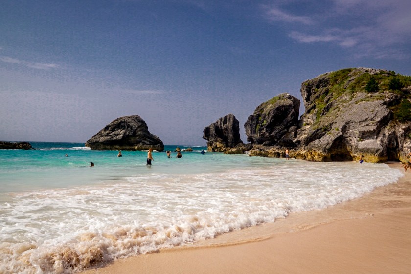
This is the island view at the base of the Lighthouse, just imaging the view from the top! However we were only given 20 minutes, not enough time to climb.  But one couple decided to climb it regardless for the Lighthouse was such an iconic destination!  You guessed right… the whole bus had to wait for them…

Every corner we turned was a photogenic view.  Golf courses there were world class.

The capital of Bermuda is City of Hamilton, lots of people go here for duty free shopping.  If you just want a few souvenirs to take home, our tour guide recommended this store–on the left hand side of the Burnaby Street as soon as we made a right turn from the Front Street, the cheapest T-shirt there was about $8 (on the cruise $10 on sale with fewer selections).

There are lots of churches on the island.  If you throw a rock randomly, you may hit the stained glass of a church! (Legend says so😉)

Here are a few of my favorites.  Heydon’s Chapel is the oldest church in Bermuda, and the smallest and most endearing.  The church was built in 1620.  ‘Sing to God,  Sing praises to His name; Lift up a song to Him who rides upon the clouds; His name is the Lord, exult before Him. Psalm 68:4.’

The Unfinished Church was planned as a replacement for St. Peter’s Church.  The construction started in mid-19th century, but left unfinished when running out of fund.  I wish we had more time to linger there, it would be a beautiful spot for wedding.

DSC05031

And St. Peter’s Church in the Town of St.  George.  This is the oldest continuously used Anglican church in the western hemisphere, more than 400 years old!

St. George is at the eastern tip of Bermuda.  The town and the surrounding fortifications as a whole is a UNESCO World Heritage site.  Lots of the sites were closed since our bus arrived after 5 pm.  St. George will be our #1 choice of lodging locations if we go back to Bermuda.

Things we might do differently:

Bermuda consists of more 180 islands, totally 20 square miles.  The Bermuda we refer to is the largest island.  You can get away from participating the cruise excursion especially you have friends and family travel together, just do your own tour.  Normally we prefer the freedom of doing our own things than taking tours since we always feel rushed with a tour.  However with a 89-year-old mom with us, bus tour was the next best thing.

At the Royal Naval Dockyard, right outside of our cruise, there were MANY taxis waiting for service.  You could pay the driver by hour, this way you have your personal driver and tour guide for your group.  Our excursion was $100/person, for the four of us we could have hired a driver for the day with a much greater amount of freedom, like climbing the Lighthouse and lingering longer at the Unfinished Church!

View this post on Instagram

Happy first day of summer!! #sailing

A post shared by Aihua (@chasingthewind2016) on