Iceland (VI): From Borgarnes to Akureyri, Part II (North)

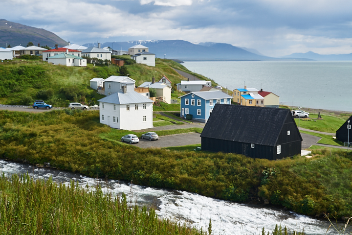
Continue north, our next town was Hofsós at the Tröllaskagi Peninsula.  Hofsós was one of my favorite small towns in Iceland.  Maybe it was because the overcasting clouds were finally cleared up when we were there; maybe it was the infinity pool or the free fish; regardless the day turned into a bright day after Hofsós.

We walked across this bridge a couple of times.  I just liked the rustic look, it remained me of a classic painting, like walking into a world of a fiction–an art realm.

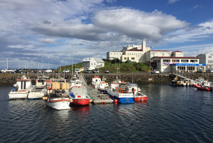
The Icelandic Emigration Center was right by the old port.  200,000 Icelandic immigrated to America from 1870-1914.  It was a time of difficulty with the volcanic eruptions and the hardship of bad cold, especially in this northern part of the country.

Strolling along the tiny harbor we met a couple.  They were cleaning fish, apparently they had just finished unloading from their boat.  It turned out they were vacationing from Reykjavik and they owned a condo in Hofsós.

This was their annual trip; every summer they came to Hofsós fishing, then froze and brought them back to Reykjavik to eat during the winter months.  We chatted and felt like we were old friends, at the end they gave us a huge haddock–no, not a “hot dog”. The gentleman gut the fish and cut it into half so we could cook it easily later on! How thoughtful!

Icelandic people are the nicest people!

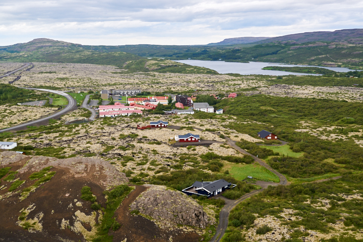
Another highlight of the town was the thermal swimming pool.  This infinity pool was a gift to the people of Hofsós by two wealthy business women.  What a panoramic view!

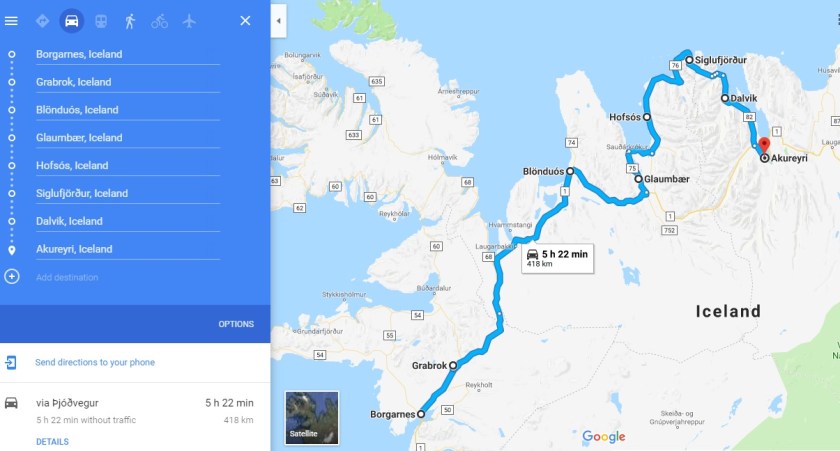
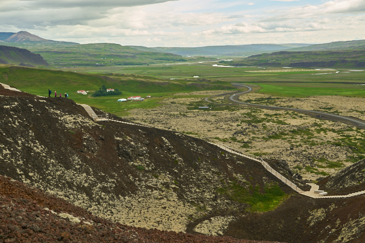
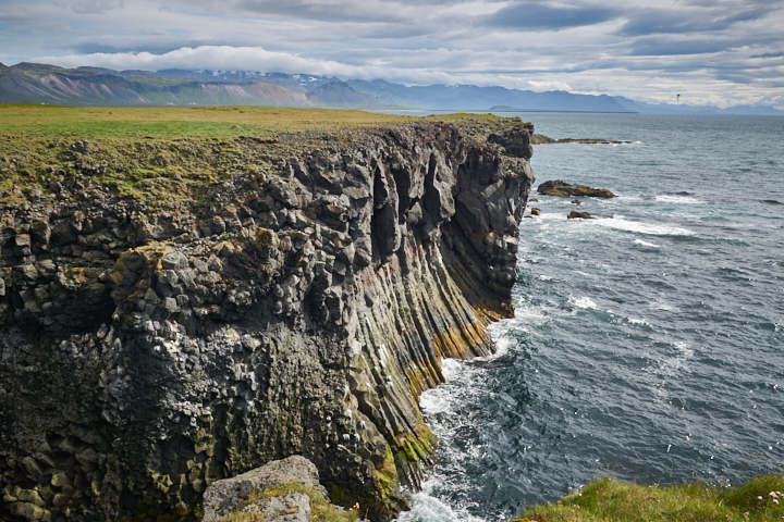
It was really hard to say good bye to Hofsós, but Akureyri was still 2.5 hours away.  The drive from Hofsós to Siglufjörður was scenic. Yet I don’t have pictures to share the parts of roads that were winding, narrow and without railings! I was holding my breath in fear of missing the turn and tumbling down to the cliffs…

There was a herring museum in Siglufjörður. We missed it because it closed at 6 pm. But we walked in town and found a grocery store, picked up a salt shaker and some fruits and bread to go with the haddock dinner.

While lingering along the road, we smelled strong scent of licorice.  I knew licorice was a popular Icelandic candy.  Immediately putting our noses to work, we bent over to smell the grass and bushes, and trying to nail down the source.

And I found the plant!  The seeds tasted very sweet, just like licorice.  Imagine my excitement about this discovery!  In my high, an Icelandic lady approached and chatted with us.  After I shared my finding with her, she smiled, yes this wild plant was indeed from a licorice family, but it was not the source of licorice candy though.  Then she pointed to the plant besides it and remarked “never put that in your mouth, it is poisonous.”

I thanked her profusely! She was the second kind person I met in one day, and she was on vacation from Reykjavik too.

There were at least three tunnels from Siglufjörður to Dalvík, some double lanes and some single lane.  It was quite an experience passing a 10-km long single lane tunnel, especially when there was a car coming right at you!

Finally we arrived at Dalvik, it was well pass 8 pm.

The last beer bath was at 8 pm.  It turned out we didn’t miss much: the beer bath was to soak in a hot tub mixed with hot spring and young beer, which had zero alcohol content. So instead of beer bath, we ordered a beer, a local-brewed authentic Icelandic beer.  It tasted just like beer.

By the time we arrived at our hotel in Akureyri at 9:30, the dinning room was already closed.  Don’t you just love long-day light in the Icelandic summer?

No microwave was provided in our hotel room, nowhere in the hotel, so we inquired the front desk.  The gentleman there was the most helpful receptionist ever! He called the kitchen and sent us there right away despite the fact the kitchen was already closed. Luckily someone was still there washing dishes. The kitchen was the only place in the whole hotel that had a microwave!

When the fish was finally put on the table, I happened to look out the window–

Akureyri4

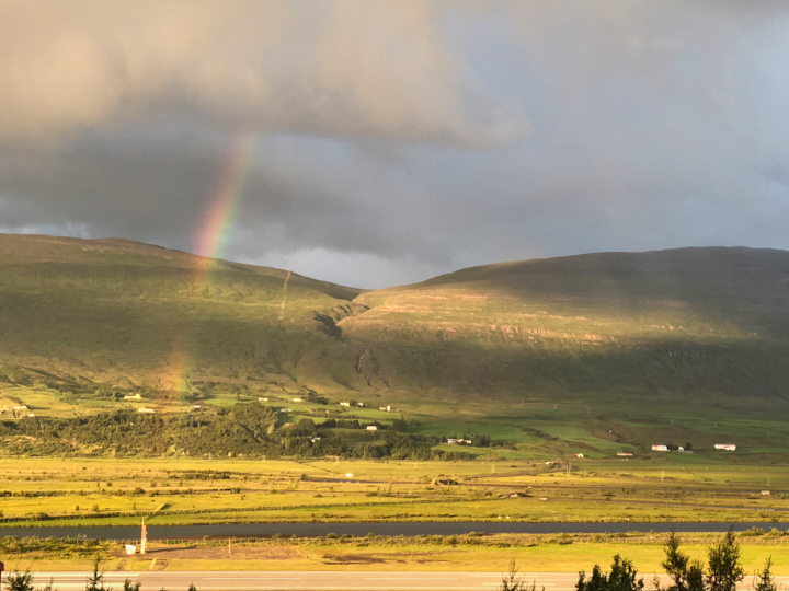
Hold the fork, I had to take pictures!!

Our first Icelandic rainbow!  Within minutes, the rainbow grew into a full arch, and then a double rainbows!  What a brilliant sight! Its warm glow invigorated our body and refreshed our spirit!

rainbow

It went on and on…  Actually we needed no rush, by the time we finished our dinner, the rainbow was still there!!

Akureyri11

It was the midnight sun, the rainbow lasted more than an hour! That was how our day ended, at a rainbow high note!

map

Now put on the door knob the “Do Not Disturb” sign, we were going to sleep in tomorrow. Good night, sweet Iceland!


Iceland (V): From Borgarnes to Akureyri, Part I (North)

It was the fourth day, we continued to circle the Ring Road to the north.  It was about 200 miles from Borgarnes to Akureyri, we made multiple stops at Bifröst, Blönduós, Glaumbær, Hofsós, Siglufjörður, Dalvík and finally Akureyri.

Our first stop was Grabrok Crater at Bifröst, 30 minutes north of Borgarnes.

Grabrok was a volcanic crater.  Newly built paths circled the entire crater rim, with the panoramic view of the surrounding areas.

To the north, beautifully shaped mountains.

Bifrost Grabrok Crater 2

To the west, a crater with similar shape and size.

Bifrost Grabrok Crater5

To the south, it was the small village Bifröst–beautiful but no rainbow bridge to Asgard.

Bifrost Grabrok Crater6

And the winding road we drove on a few minutes ago.

This site would be much nicer visit in a clear and calm day.  For a few instants, I was afraid to get blown into the crater pit by the wind! Other than that it was really fun to walk around the rim.

Bifrost Grabrok Crater7

Back to the road, there were many farm animals grazing under the big Icelandic sky–cows, horses, and lot of sheep.

Blonduos2

Do you know there are about 800,000 sheep and lambs in Iceland, a country with the population of just 323,000?!  To our surprise, most of the sheep we saw were small group of 3 to 5, not a large flock.

Our next town was Blönduós.  We saw kids jumping on a rainbow “trampoline”.

Here was our first encounter of black sand beach.  Cold and windy, we were the only souls on the beach! Haha yes, silly tourists.

Continuing north, we caught sight of a forest of young trees. There were the first seedlings we saw since arrival to this country.  Later on we learned from the museum guide that a great effort of replanting was on going in the country.  Most of the young trees were imported from oversea.  Can you imagine the island used to be covered by forests before human settled here?  It was understood that woods were cut down to use as fuels to combat cold.

Glaumbaer1

Another phenomenon we found out unique to Iceland: the center of any settlement, such as a village, a small town even just a couple of houses, was always a church.  Many churches were simple and in the same style: white body with red roof and a steeple.

Our next stop was Glaumbær in Skagafjörður. We went to visit a classic turf farm-museum.  You see, a church in the town center.

The farm museum was very interesting, the houses were covered with sods and grass.

There were at least 12 rooms connecting together, bedrooms for the farmer and his wife and their children, kitchen, storage rooms and many more.  The yellow brick building was a gift shop with a cozy cafe.

To be continued…

Iceland (IV): the Snæfellsjökull National Park (West)

One of the highlights of the Snæfellsnes Peninsula was the Snæfellsjökull National Park.  There are only three national parks in Iceland, the Snæfellsjökull NP is the small one in the west.  It is a must-see in my opinion.

We drove to the Snæfellsnes peninsula from Borgarnes. The scenery was stunning.

Every turn provided photo moments!

Mountains and no-name waterfalls.

Our plan for the morning was to visit three coastal towns–Arnarstapi, Hellnar and Londrangar and hiked in those areas.

We reached our first destination, Arnarstapi, in about one hour.

Arnarstapi was like a paradise on Earth! The beauty of her coastal cliffs blew my mind!

arnarstapi 5

I’d let the pictures do the talking…

This monument was to represent the guardian spirit Bardur Snæfellsas, the legendary deity of Mt. Snæfell.  According to the Saga, Bardur Snaefellsas was a descendant of giant and men, local people believe his spirit live in the Snaefellsjokull, a volcano mountain covered with glacier.

hellnar 1

From Arnarstapi you could hike to the next town Hellnar along the striking coastal trail.  We didn’t want to come back to get our car, so we only hiked half way, then drove to Hellnar instead.

I have no idea what Hellnar means in Icelandic, but the pebbles, the caves and the rock patterns down there were from a different world!

hellnar 3

The daredevil inside of me decided to walk to the top of the bridge.

The view was stunning, but I had to come down before the vertigo turned my legs to spaghetti noodles!

See the path between the red house (a nice local restaurant) and the blue house, that was the hiking trail to Arnarstapi.

Our next stop was Londrangar Basalt cliffs.

You could hike all the way to the lighthouse.

Near the parking lot was the unobstructed view of the Mt. Snaefell.

If you are interested in the rest of our journey through Snaefellsness Peninsula, please check my previous blogs.

About West Iceland:

(1) We stationed in Borgarnes for two nights while touring the West Iceland, which saved us two hours of round trip per day since we didn’t stay in Reykjavik.  Our Airbnb in Borgarnes was lovely.

(2) Since it was late July, the sky was not fully dark at 2:30 am (below top right) and the Sunrise at 4 am (lower right).  An eye-mask is a must if you want to get some sleep since the Icelandic curtains were not blocking any light.

(3) Our first day’s itinerary included hiking the Glymur,  Hraunfossar and Barnafoss and Krauma thermo bath at Reykholt.  And we had Snæfellsnes Peninsula and Viking sushi tour in Stykkisholmur on the second day.  Because sushi tour was in the afternoon at 3:30, we had to sacrifice Djúpalónssandur Beach and Skarðsvík Beach.  In retrospect, we could have made it if we got up an hour earlier, but we were on vacation…

Iceland (III): the Viking Sushi Tour (West)

If you plan to visit just one town in the Snaefellsness Peninsula, I recommend Stykkisholmur. Arthur and I love seafood and sushi, so imagine our excitement when I found out about the Viking Sushi tour in town!

It was a sunny afternoon, blue sky at 55F, the weather couldn’t be better.

Bundled up in warm layers, we enjoyed ourselves up on the deck. If you don’t like wind and cold, they provided inside cabin downstairs to keep you warm and cozy.

We sailed pass a couple of small islets, our captain navigated the boat so close to the shore we could almost touch the cliff!

We saw three different kinds of birds nesting on the cliff, no puffins though.

The islets were delightful.  However, the crowning point of the tour was neither the birds nor the beautiful scenery!

Raw seafood tasting, Viking style, stole the show!

A big net was thrown into the ocean, then dragged up a few minutes later, taking with it a rich load of goodies!

There were scallops, sea urchins, starfish, crabs and mussels. Right on the boat they just cracked open the scallops and sea urchins, and handed over the scallop meat and roe of sea urchins to us!

And soy sauce, wasabi, ginger and chopsticks were provided.

We had NEVER had anything like that, so FRESH and so DELICIOUS!

Look at all the empty shells on the table!

The red sea urchin was pretty, but not edible. Also the mussels were not suitable to eat raw either.

We couldn’t finish them all, at the end the unconsumed sea creatures and all the empty shells got returned back to the ocean where they belonged.

IMG_1356(p)

The tour lasted two and half hours. Since we couldn’t have mussels on the boat, we had steamed Icelandic blue mussels for dinner at a restaurant by the dock.  It was nice to dine on cooked food again, hard to sustain on Viking diet.

Our tummies were full.  Content and sated. Let’s call it a day!

Iceland (II): the Iconic Image of Mt. Kirkjufell

How to capture the iconic image of Mt. Kirkjufell and Kirkjufellfoss

Mt. Kirkjufell together with the Kirkjufell waterfall has become the iconic image of West Iceland, taking this shot was on my list of must-do in Iceland.

Only when I got to the location, I learned just how particular this shot was.

Mt. Kirkjufell #1

If you came from Snaefellsjokull National Park direction like us, Mt. Kirkjufell had no tip but a flat top.  The mountain displayed its iconic shape only at the angle after we passed it.

Mt. Kirkjufell #2

Not only that, the Kirkjufellsfoss, the waterfalls, were on the other side of the road.

The waterfalls were not by the mountain at all.

Mt. Kirkjufell #3

This shot was taken from the small bridge on top of Kirkjufell waterfalls; Kirkjufell mountain was on the other side of the road, left to the parking lot.

Only when you crossed the small bridge, standing on the left side (where all the people standing), then angled your camera to include both the mountain and the falls–Voila, you got the shot!

Mt. Kirkjufell and Kirkjufellsfoss

Ideally, during the sunset is the optimal time of the day to shoot Mt. Kirkjufell.  You would have colorful sky as the backdrop. We were not lucky that day.

On the way to Mt. Kirkjfell, Grudarfjordur, we stopped at Olafvik for lunch.  There we found a local soccer field.

Olafvik Soccer field #1

And an ultra modern church by the soccer field.

Olafvik Church

Mountains, glaciers, waterfalls, clean air and church, all must have somehow contributed to the outstanding performance of Icelandic soccer team in 2018 World Cup!